

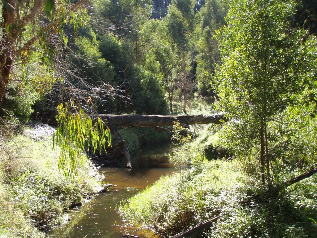
The Gellibrand River is the backbone of the Otways, supporting life, primary industry and recreation activities. The values include a designated water supply catchment, threatened species, significant ecological vegetation communities, cultural values and diverse recreational activities. The threats to these values include grazing pressures on riparian zones and water quality, impacts of the likelihood of increasing natural disasters associated to flood and fire under a changing climate, reduction in flows over the summer months due to extraction as well as pest plant and animal (willow and fox).
The Corangamite Catchment Management Authority (CMA) has had a long history of working with community groups, landowners, government agencies, universities and agricultural industries in improving the health of this river system.
The Delivering Integrated Catchment Management for the Gellibrand Project aims to improve the waterway health of the Gellibrand River by building on past work to create a more targeted integrated catchment management approach that will enable leveraging, knowledge sharing and co-ordination of priority actions. The development of a waterway health plan with key stakeholders will inform the ongoing investment within the Gellibrand that covers the designated Water Supply catchment, major tributaries estuary. This will be achieved through on-ground works, community engagement and an Environmental Water Reserve Officer (EWRO) working with Wannon Water to improve environmental flows.
This project covers the priority reaches within Gellibrand catchment area including the Designated Water Supply Catchment, priority tributaries (Chapple, Sandy, Carlisle, Gum Gully, Love, Kennedys), and the Gellibrand estuary.
This project is funded by the Victorian Government under the fifth tranche of the Environmental Contribution.
A catchment planning process, based on INFERR prioritisation is be undertaken to develop a Waterway Health Plan for the Gellibrand catchment, in collaboration with various stakeholders including West Vic Dairy, Ag Vic, Heytsbury District Landcare Network, Central Otways Landcare Network Barwon and Wannon Water, Eastern Maar.
Once finalised, the Plan will outline priorities for future action by Corangamite CMA and other stakeholders and help enable additional funds to be leveraged for on ground management into the future.
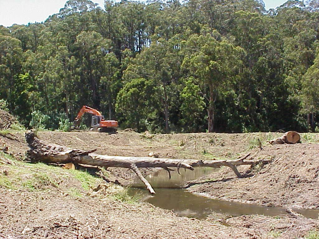
Field officers, in collaboration with Heytesbury District Landcare Network and Central Otways Landcare Network, will monitor past on-ground works sites with the priority being past willow project sites, to ensure management agreements are being maintained.
New landholder incentives will become available, and education and incentives will be targeted to land managers and community groups to undertake on-ground riparian restoration works, supported by one-on-one landholder engagement for project negotiation, ongoing management advice and education on riparian management.
Education and access to Country for Traditional Owners will be negotiated with landholders at 2 sites, further details to come.
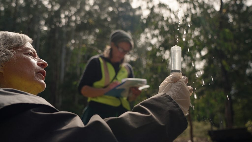
Citizen Science aims to maintain and improve the connections between people and their local waterways. This is undertaken through diverse hands-on activities, such as monitoring water quality, photopoint monitoring at key sites, or e-DNA sampling.
The citizen science program is critical to engagement and awareness of volunteers, school groups and Traditional owner groups within the Gellibrand Catchment, and the data collected will help inform project delivery within the catchment.
Find out more about Citizen Science here.
Maintaining the active EstuaryWatch group for the Gellibrand is critical to understanding the impacts of the catchment activities as well as estuary openings, and the citizen science work through Waterwatch strengthens our community partnerships with Landcare Networks and Eastern Maar Traditional Owners.
A number of different agencies work together to deliver outcomes for the Curdies River estuary. Their roles are explained below.
u003cspan class=u0022NormalTextRun SCXW180068515 BCX8u0022u003eParks Victoria is the land manager of the Curdies River estuary. This includes responsibilities for opening the estuary if u003c/spanu003eu003cspan class=u0022NormalTextRun SCXW180068515 BCX8u0022u003efeasibleu003c/spanu003eu003cspan class=u0022NormalTextRun SCXW180068515 BCX8u0022u003e and desirable to protect areas from flooding. Parks Victoria must obtain a permit from Corangamite CMA prior to any artificial estuary openings.u003c/spanu003e
u003cspan data-contrast=u0022noneu0022u003eUnder the Environment Protection Act 2017 (s25) General Environmental Duty (GED), anyone engaging in activities that may give rise to risks of harm to human health or the environment from pollution or waste needs to understand those risks and take reasonably practicable steps to minimise them. u003c/spanu003eu003cspan data-ccp-props=u0022{u0026quot;201341983u0026quot;:0,u0026quot;335559739u0026quot;:0,u0026quot;335559740u0026quot;:276}u0022u003e u003c/spanu003ernrnu003cspan data-contrast=u0022noneu0022u003eThe EPA provides guidance to dairy farmers on how to assess and meet their GED obligations, such as the u003ca href=u0022https://www.epa.vic.gov.au/about-epa/publications/1819-1#:~:text=This%20guide%20outlines%20how%20to%20manage%20the%20risks,can%20take%20to%20comply%20with%20the%20new%20laws.u0022u003eAgriculture - guide to preventing harm to people and the environmentu003c/au003e. EPA also references more detailed guidance from the Department of Agriculture and Dairy Australia’s Dairy Gains program. Dairy farms do not require specific EPA permission to manage effluent in lagoon systems and irrigate to paddocks. The EPA recently undertook an audit of 25 dairy farms and found 2 out of 25 farms were not meeting their obligations. u003c/spanu003ernrnu003cstrongu003eThe public and agencies should report all fish death events to EPA by calling 1300 EPA VIC (1300 372 842), 24 hours a day. u003c/strongu003ernrnu003cspan data-contrast=u0022autou0022u003eEPA will assess and triage the report considering size of the event, species, location, potential cause and other relevant factors. If the cause of the fish death is a result of a specific pollution event, then EPA officers will respond directly to investigate. If it is likely the cause is a natural occurrence, EPA may request assistance or refer the report to other agencies with water or land management responsibilities. u003c/spanu003eu003cspan data-ccp-props=u0022{u0026quot;201341983u0026quot;:0,u0026quot;335559739u0026quot;:160,u0026quot;335559740u0026quot;:259}u0022u003e u003c/spanu003e
u003cspan class=u0022TextRun SCXW176748621 BCX8u0022 lang=u0022EN-AUu0022 xml:lang=u0022EN-AUu0022 data-contrast=u0022noneu0022u003eu003cspan class=u0022NormalTextRun SCXW176748621 BCX8u0022u003eWannon Water is an urban water corporation.u003c/spanu003eu003c/spanu003eu003cspan class=u0022TextRun SCXW176748621 BCX8u0022 lang=u0022EN-AUu0022 xml:lang=u0022EN-AUu0022 data-contrast=u0022autou0022u003eu003cspan class=u0022NormalTextRun SCXW176748621 BCX8u0022u003e They u003c/spanu003eu003c/spanu003eu003cspan class=u0022TextRun SCXW176748621 BCX8u0022 lang=u0022EN-AUu0022 xml:lang=u0022EN-AUu0022 data-contrast=u0022noneu0022u003eu003cspan class=u0022NormalTextRun SCXW176748621 BCX8u0022u003edon’tu003c/spanu003eu003cspan class=u0022NormalTextRun SCXW176748621 BCX8u0022u003e extract water from the Curdies River for drinking water purposes and u003c/spanu003eu003cspan class=u0022NormalTextRun SCXW176748621 BCX8u0022u003edon’tu003c/spanu003eu003cspan class=u0022NormalTextRun SCXW176748621 BCX8u0022u003e have a land or waterway management role in the Curdies River catchment. u003c/spanu003eu003c/spanu003eu003cspan class=u0022TextRun SCXW176748621 BCX8u0022 lang=u0022EN-USu0022 xml:lang=u0022EN-USu0022 data-contrast=u0022autou0022u003eu003cspan class=u0022NormalTextRun SCXW176748621 BCX8u0022 data-ccp-charstyle=u0022normaltextrunu0022 data-ccp-charstyle-defn=u0022{u0026quot;ObjectIdu0026quot;:u0026quot;525bcbfc-f244-46ae-af56-4b80fa7ae03c|28u0026quot;,u0026quot;ClassIdu0026quot;:1073872969,u0026quot;Propertiesu0026quot;:[469775450,u0026quot;normaltextrunu0026quot;,201340122,u0026quot;1u0026quot;,134233614,u0026quot;trueu0026quot;,469778129,u0026quot;normaltextrunu0026quot;,335572020,u0026quot;1u0026quot;,469778324,u0026quot;Default Paragraph Fontu0026quot;]}u0022u003eWannonu003c/spanu003eu003cspan class=u0022NormalTextRun SCXW176748621 BCX8u0022 data-ccp-charstyle=u0022normaltextrunu0022u003e Water is the Blue-green Algae Regional Coordinator for the area including the Curdies River. The Regional Coordinator u003c/spanu003eu003cspan class=u0022NormalTextRun SCXW176748621 BCX8u0022 data-ccp-charstyle=u0022normaltextrunu0022u003eis responsible foru003c/spanu003eu003cspan class=u0022NormalTextRun SCXW176748621 BCX8u0022 data-ccp-charstyle=u0022normaltextrunu0022u003e ensuring there is a coordinated management response for local Blue-green Algae blooms and planning and preparedness for managing regional blooms. u003c/spanu003eu003cspan class=u0022NormalTextRun SCXW176748621 BCX8u0022 data-ccp-charstyle=u0022normaltextrunu0022u003eWannonu003c/spanu003eu003cspan class=u0022NormalTextRun SCXW176748621 BCX8u0022 data-ccp-charstyle=u0022normaltextrunu0022u003e Water u003c/spanu003eu003cspan class=u0022NormalTextRun SCXW176748621 BCX8u0022 data-ccp-charstyle=u0022normaltextrunu0022u003eareu003c/spanu003eu003cspan class=u0022NormalTextRun SCXW176748621 BCX8u0022 data-ccp-charstyle=u0022normaltextrunu0022u003e a provider of u003c/spanu003eu003cspan class=u0022NormalTextRun SCXW176748621 BCX8u0022 data-ccp-charstyle=u0022normaltextrunu0022u003esewerageu003c/spanu003eu003cspan class=u0022NormalTextRun SCXW176748621 BCX8u0022 data-ccp-charstyle=u0022normaltextrunu0022u003e services and operator of the Peterborough Sewerage Scheme.u003c/spanu003eu003c/spanu003e
u003cspan data-contrast=u0022autou0022u003eDEECA is the Control Agency for Blue-green Algae and develops the policy for overall Blue-green Algae management in Victoria. DEECA collects data on BGA to monitor trends throughout the State which helps to manage BGA blooms. During an algal bloom, DEECA will co-ordinate management activities so that all relevant stakeholders can perform their respective roles and responsibilities at the regional level. More information can be found on the DELWP BGA page: u003c/spanu003eu003ca href=u0022https://www.water.vic.gov.au/waterways-and-catchments/rivers-estuaries-and-waterways/blue-green-algaeu0022u003eu003cspan data-contrast=u0022noneu0022u003ehttps://www.water.vic.gov.au/waterways-and-catchments/rivers-estuaries-and-waterways/blue-green-algaeu003c/spanu003eu003c/au003eu003cspan data-contrast=u0022autou0022u003e u003c/spanu003eu003cspan data-ccp-props=u0022{u0026quot;134233117u0026quot;:false,u0026quot;134233118u0026quot;:false,u0026quot;201341983u0026quot;:0,u0026quot;335559738u0026quot;:0,u0026quot;335559739u0026quot;:0,u0026quot;335559740u0026quot;:276}u0022u003e u003c/spanu003ernrnu003cspan data-contrast=u0022autou0022u003eDEECA is also performing the role of Local Water Manager for Blue-green Algae in the Curdies River. Local Water Managers are responsible for managing BGA blooms in the section of a waterway or water body they are responsible for, particularly to minimise impacts of the bloom including public health risks through monitoring, communications and reporting. u003c/spanu003eu003cspan data-ccp-props=u0022{u0026quot;201341983u0026quot;:0,u0026quot;335559739u0026quot;:160,u0026quot;335559740u0026quot;:259}u0022u003e u003c/spanu003ernrnu003cspan data-contrast=u0022autou0022u003eAgriculture Victoria is part of DEECA and works in partnership with industry groups and local farmers to improve farm practices. Thy also undertake preliminary investigations in the case of cattle deaths. u003c/spanu003eu003cspan data-ccp-props=u0022{u0026quot;201341983u0026quot;:0,u0026quot;335559739u0026quot;:160,u0026quot;335559740u0026quot;:259}u0022u003e u003c/spanu003e
u003culu003ern tu003cli data-leveltext=u0022u0022 data-font=u0022Symbolu0022 data-listid=u00222u0022 data-list-defn-props=u0022{u0026quot;335552541u0026quot;:1,u0026quot;335559684u0026quot;:-2,u0026quot;335559685u0026quot;:720,u0026quot;335559991u0026quot;:360,u0026quot;469769226u0026quot;:u0026quot;Symbolu0026quot;,u0026quot;469769242u0026quot;:[8226],u0026quot;469777803u0026quot;:u0026quot;leftu0026quot;,u0026quot;469777804u0026quot;:u0026quot;u0026quot;,u0026quot;469777815u0026quot;:u0026quot;hybridMultilevelu0026quot;}u0022 aria-setsize=u0022-1u0022 data-aria-posinset=u00221u0022 data-aria-level=u00221u0022u003eu003cspan data-contrast=u0022noneu0022u003eCorangamite CMA is the permitting authority for estuary openings and undertakes a risk-based assessment that considers environmental, social and economic values of the estuary prior to providing a permit. u003c/spanu003eu003cspan data-ccp-props=u0022{u0026quot;201341983u0026quot;:0,u0026quot;335559739u0026quot;:160,u0026quot;335559740u0026quot;:259}u0022u003e u003c/spanu003eu003c/liu003ernu003c/ulu003ernu003culu003ern tu003cli data-leveltext=u0022u0022 data-font=u0022Symbolu0022 data-listid=u00222u0022 data-list-defn-props=u0022{u0026quot;335552541u0026quot;:1,u0026quot;335559684u0026quot;:-2,u0026quot;335559685u0026quot;:720,u0026quot;335559991u0026quot;:360,u0026quot;469769226u0026quot;:u0026quot;Symbolu0026quot;,u0026quot;469769242u0026quot;:[8226],u0026quot;469777803u0026quot;:u0026quot;leftu0026quot;,u0026quot;469777804u0026quot;:u0026quot;u0026quot;,u0026quot;469777815u0026quot;:u0026quot;hybridMultilevelu0026quot;}u0022 aria-setsize=u0022-1u0022 data-aria-posinset=u00221u0022 data-aria-level=u00221u0022u003eu003cspan data-contrast=u0022noneu0022u003eCorangamite CMA also works with private landholders to undertake catchment improvement works through implementing the Corangamite Waterways Strategy. u003c/spanu003eu003cspan data-ccp-props=u0022{u0026quot;201341983u0026quot;:0,u0026quot;335559739u0026quot;:160,u0026quot;335559740u0026quot;:259}u0022u003e u003c/spanu003eu003c/liu003ernu003c/ulu003e
Curdies River Update - June 2023
Curdies River Community Update - April 2023
Curdies River Community update - March 2023
Curdies River Community Update - January 2023
Curdies River Community Update - December 2022
Curdies River Community Update - November 2022
Curdies River Community Forum - October 2022
Curdies River Community Update - August 2022


64 Dennis Street, Colac VIC 3250
PO Box 159, Colac, VIC 3250
Hours: 8:30am – 5pm, Monday to Friday
T: 1800 002 262
E: info@ccma.vic.gov.au
BARWON WATER OFFICES
Hours: 8:30am – 5pm, Monday to Friday
All mail must be sent via our Colac office
PO Box 159, Colac, VIC 3250
T: 1800 002 262
E: info@ccma.vic.gov.au
 Close
Close